
Geology Rocks I: Can you isolate a single day in geological history?
Figuring out what happened the day the dinosaurs died, missed opportunities for Fred Flintstone vs Leon Limestone jokes, and the perfect conditions for an unlikely discovery.

This article popped up on my Twitter feed a few weeks ago:

I wasn’t surprised to see it based on the number of science accounts I follow and the relentless churn of the algorithm. It was for those same reasons, however, that I was surprised I hadn’t seen it before. Douglas Preston’s piece is a 10,000+ word masterclass on prehistoric storytelling, a character study of a scientific underdog, and a first-person account of what it was like to start rewriting the most significant moments of the earth’s geological record.
A lot has happened between this issue of The New Yorker from 2019 and today. It doesn’t matter why this piece stayed unbeknownst to me for two years. What matters is that the first three paragraphs felt like time traveling. The scene pulled me in so fast that I had no choice but to absorb the whole thing in one sitting. And then again a few days later.
The passage in question:
If, on a certain evening about sixty-six million years ago, you had stood somewhere in North America and looked up at the sky, you would have soon made out what appeared to be a star. If you watched for an hour or two, the star would have seemed to grow in brightness, although it barely moved. That’s because it was not a star but an asteroid, and it was headed directly for Earth at about forty-five thousand miles an hour. Sixty hours later, the asteroid hit. The air in front was compressed and violently heated, and it blasted a hole through the atmosphere, generating a supersonic shock wave. The asteroid struck a shallow sea where the Yucatán peninsula is today. In that moment, the Cretaceous period ended and the Paleogene period began.
A few years ago, scientists at Los Alamos National Laboratory used what was then one of the world’s most powerful computers, the so-called Q Machine, to model the effects of the impact. The result was a slow-motion, second-by-second false-color video of the event. Within two minutes of slamming into Earth, the asteroid, which was at least six miles wide, had gouged a crater about eighteen miles deep and lofted twenty-five trillion metric tons of debris into the atmosphere. Picture the splash of a pebble falling into pond water, but on a planetary scale. When Earth’s crust rebounded, a peak higher than Mt. Everest briefly rose up. The energy released was more than that of a billion Hiroshima bombs, but the blast looked nothing like a nuclear explosion, with its signature mushroom cloud. Instead, the initial blowout formed a “rooster tail,” a gigantic jet of molten material, which exited the atmosphere, some of it fanning out over North America. Much of the material was several times hotter than the surface of the sun, and it set fire to everything within a thousand miles. In addition, an inverted cone of liquefied, superheated rock rose, spread outward as countless red-hot blobs of glass, called tektites, and blanketed the Western Hemisphere.
Some of the ejecta escaped Earth’s gravitational pull and went into irregular orbits around the sun. Over millions of years, bits of it found their way to other planets and moons in the solar system. Mars was eventually strewn with the debris—just as pieces of Mars, knocked aloft by ancient asteroid impacts, have been found on Earth. A 2013 study in the journal Astrobiology estimated that tens of thousands of pounds of impact rubble may have landed on Titan, a moon of Saturn, and on Europa and Callisto, which orbit Jupiter—three satellites that scientists believe may have promising habitats for life. Mathematical models indicate that at least some of this vagabond debris still harbored living microbes. The asteroid may have sown life throughout the solar system, even as it ravaged life on Earth.
The gobsmacking, bamboozling evidence of an asteroid strike that killed over 99.9999% of living things on the planet was revealing itself again. And this time, it was more detailed and in more unexpected places than scientists on the beat had ever seen before. This time, the geological record got close to the single catastrophic moment thanks to the lucky convergence of fluid dynamics, extreme conditions, and natural preservation conditions that rarely exist on Earth.
Today we’re talking about the lengths it takes to narrow down physical geological evidence to a single day. What do scientists even look for and where? Is it even possible to isolate such short time periods on a geologic scale?
The short answer is that it can be done. The catch is that it’s contingent on what type of events occurred and you can only find it if you know where to look.
Two last housekeeping notes before we dig into some geological history!
First, the Amateurist is a completely independent and reader-supported newsletter. Thanks to the generous support of paid subscribers, I can do things like access paid academic journal articles, buy blue light glasses to protect my eyeballs, and offset the time it takes to write these pieces that I’d otherwise be devoting to freelance clients. To the paid Amateurs reading, thank you so much!
If you’re interested in throwing your own dollars behind an indie publication, I’m offering a springtime discount that will save you 20% on a standard subscription. That’s only $4 a month ($2 or less per article!) or $44 a year ($1.83 or less per article!) that will go toward operating costs. Paid subscribers also get access to exclusive content from my upcoming book.
This option is available until April 1 and lasts as long as the subscription is active. You can also give it as a gift to the science lovers in your life!
Second, I quite like The New Yorker as a publication. It’s home to many, many talented writers and a few of my favourite pieces of all time. But seeing as much of the content lives behind a paywall and I’m careful with money, I take my five free articles a month seriously and ration them with the utmost discipline.
If it’s not likely to blow my mind, I won’t be clicking. I can’t (nay, I won’t) risk it.
The piece that spurred on this newsletter is worth clicking, though. If you’re like me and don’t have any free articles left this month, let me help you out. I’ve dropped the full article for you to read here in defiance of paywalls everywhere. It’s also available in its original format here.
Come back when you’re done, okay? Maybe I should have put this at the bottom. Oh well.
Now for the good stuff!
First we’re going to establish how scientists can even determine the timeline for when major geological events happened. We’ll be using the asteroid strike from 66 million years ago as the example. From Douglas Preston’s piece:
The asteroid was vaporized on impact. Its substance, mingling with vaporized Earth rock, formed a fiery plume, which reached halfway to the moon before collapsing in a pillar of incandescent dust. Computer models suggest that the atmosphere within fifteen hundred miles of ground zero became red hot from the debris storm, triggering gigantic forest fires. As the Earth rotated, the airborne material converged at the opposite side of the planet, where it fell and set fire to the entire Indian subcontinent. Measurements of the layer of ash and soot that eventually coated the Earth indicate that fires consumed about seventy per cent of the world’s forests. Meanwhile, giant tsunamis resulting from the impact churned across the Gulf of Mexico, tearing up coastlines, sometimes peeling up hundreds of feet of rock, pushing debris inland and then sucking it back out into deep water. […]
Earth itself became toxic. When the asteroid struck, it vaporized layers of limestone, releasing into the atmosphere a trillion tons of carbon dioxide, ten billion tons of methane, and a billion tons of carbon monoxide; all three are powerful greenhouse gases. The impact also vaporized anhydrite rock, which blasted ten trillion tons of sulphur compounds aloft. The sulphur combined with water to form sulphuric acid, which then fell as an acid rain that may have been potent enough to strip the leaves from any surviving plants and to leach the nutrients from the soil.
The events at the Cretaceous-Paleogene boundary (otherwise known as the KT boundary or the K-Pg extinction event) created enormous amounts of visible debris and contributed so much new and unusual material to the planet over such a short period that there’s no better example of mapping the geologic time scale. It helps that it’s also an isolated event and easy to spot in the physical world today.
Most geological time periods can be measured using the earth’s crust as a kind of epoch rolodex, thanks to somewhat organized layers, signature mineral deposits, and other paleontological evidence like fossils. The eras starting with the three most commonly associated with dinosaurs (the Mesozoic era) until today (the Cenozoic era) are particularly identifiable thanks to their relative youth and unique characteristics:
The Triassic period (252-201 million years ago [Mya]) is named for its three distinctive layers found in rock from this era. Iron-rich red sandstone rock beds make up the base because the climate was mostly hot and dry on the supercontinent Pangaea while it bounced back from an extinction event.
The next layer is marine limestone that has higher concentrations of calcium from things like skeletal fragments and crustacean shells. It’s also often high in calcite and silica, which are great candidates for radiometric dating (measuring the age of old stuff).
The third Triassic layer is made up of a collection of mudstone, sandstone, and basaltic rocks that point to increasing humidity from about 228 to 205 Mya.
The Jurassic period (201-145 Mya) is the heyday of the dinosaurs. It’s demarcated by limestone strata and the presence of new families of mollusk-like fossils called ammonites, which were basically decimated at the end of the Triassic. Along with those, flying vertebrates and an explosion of aquatic crocodilians arrived. Pangaea began to split into two smaller land masses during this time, which increased humidity in formerly arid regions. Think lush green rainforests, shallow lagoons and expanding coastal regions home to enormous amounts of life.
Since biodiversity boomed in the Jurassic, there were many more opportunities for organisms to live and die. Marine rocks became calcified and the remains of organisms became some of the largest sources of hydrocarbons (oil and coal) in the world. The Jurassic-era limestone deposit in the Arabian Intrashelf Basin is the world’s largest oil reserve.
The Cretaceous period (145-66 Mya) was similar to the Jurassic in lots of ways. Where the Jurassic saw the rise of both land-dwellers and marine life, the Cretaceous tended toward a more aquatic and reptilian-friendly situation.
Tectonic plates continued to shift apart and created tons of new waterways and reservoirs in their wake. A warm climate (upwards of 8 degrees warmer than today) and high sea levels (+75m or more!) meant lots of inland regions were covered in warm shallow seas that supported diverse ecosystems. Here, marine limestone was plentiful thanks to all the chalk deposits and easy sedimentation (that’s where particles can settle and become layered).
Elsewhere, deep sea currents were largely stagnant. This limited organic decomposition due to a lack of oxygen in the water. When things like bones, algae, and phytoplankton can’t decompose, they become part of the sedimentation process and get buried under immense pressure over millions of years. Eventually, they become liquefied. These regions, just like the limestone deposits from the Jurassic, now represent about half of the world’s oil reserves.
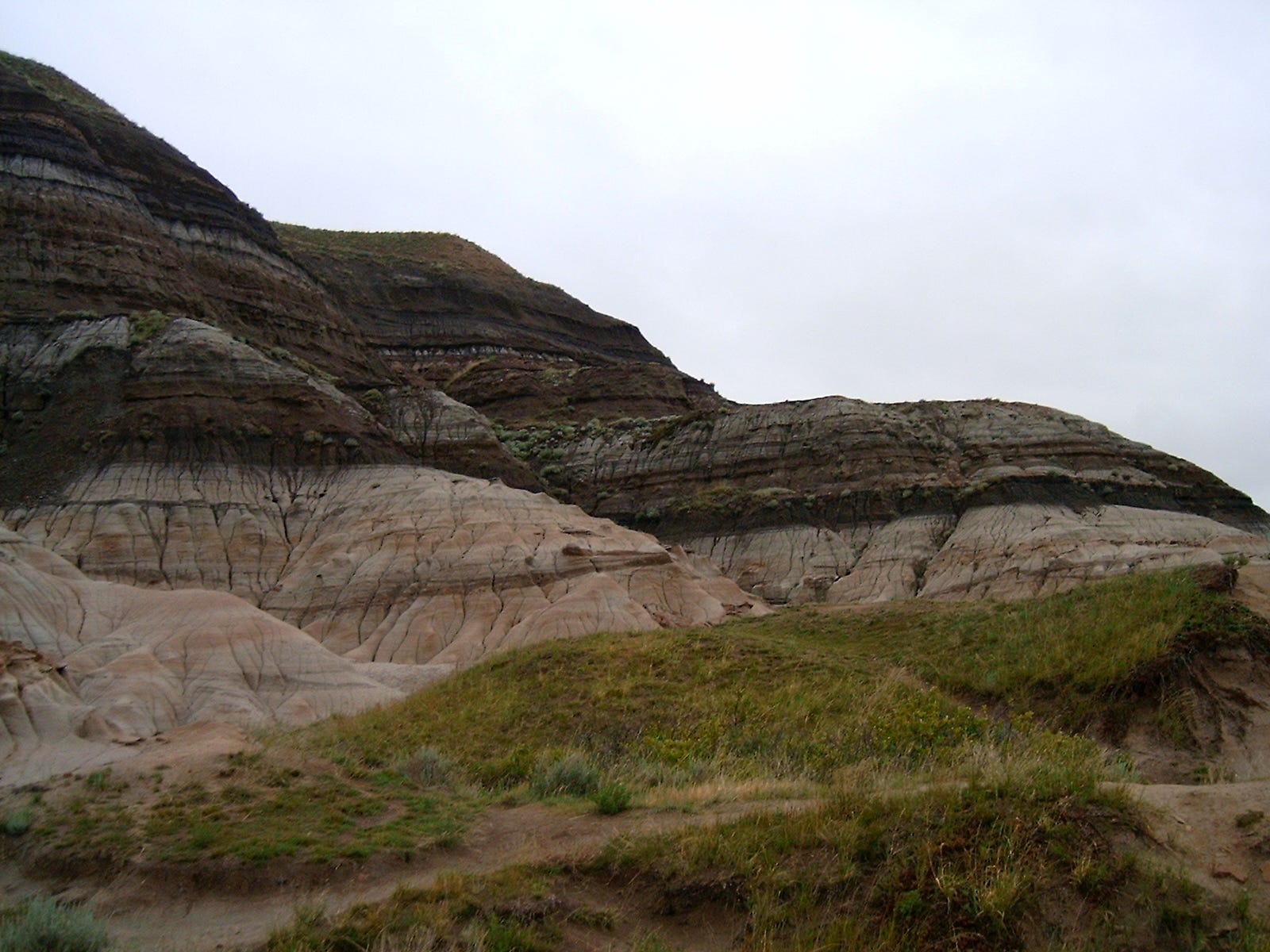
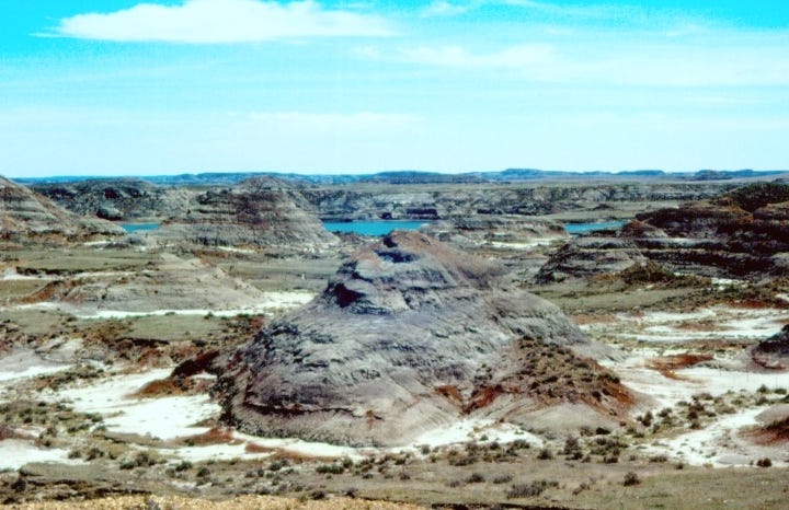
The ecological riches of the Cretaceous came to an abrupt end 66.043 Mya, when an asteroid between 10 and 15 km across struck the Yucatán Peninsula and triggered a mass extinction that gave rise to the age of mammals, birds, and eventually humans. The black stripe of death and destruction is easy to spot where conditions allow, like in areas where erosion has revealed layers from that era. This is evident in Drumheller, AB and the Hell Creek geological formation (above) that pops up in the Dakotas, Montana, and Wyoming.
Unsurprisingly, once up an epoch, this is where Preston says there were “steamy, subtropical lowlands and floodplains along the shores of an inland sea. The land teemed with life and the conditions were excellent for fossilization, with seasonal floods and meandering rivers that rapidly buried dead animals and plants.”
Today, most the dozens (!!) of subsequent periods and epochs following the K-Pg boundary are measured by the fossil record. The scientific community has a well-established roster of organisms and mineral combinations that were plentiful during certain time periods, so the presence or absence of any of them is enough to offer an educated guess for age.
Of course, radiometric dating is still common when the fossil record isn’t conclusive enough. Methods like uranium-lead dating and potassium-argon dating are suitable for determining the age of things between 2 million and 2.5 billion years old, within a few percentage points.
The single most challenging thing about measuring geological time is that most of the rocks from more than one or two billion years ago have been either eroded away or lost to the earth’s mantle in a slow pattern of re-absorption and tectonic plate subduction. The bits and pieces that are still around from that era are few and far between, with many of them coming from “geologic shield” regions of Canada, Australia, and Africa. The oldest known rock originating from Earth is from the Canadian Shield and it’s about 4 billion years old. In geologic time, that’s between 1 and 2 o’clock; we’re talking old old. [The oldest rock ever? 7 billion years old. Older than the sun.]
From about 1 billion years ago onward, there’s fairly good geologic evidence out there, but only to a point. Other than supereons, which we’re not going to talk about, the longest intervals in geologic time are eons, that spanning hundreds of millions of years. The first three eons, or about 88% of the earth’s history, don’t have much information to be gathered from their rocks other than mountain building, oxygenating, and you know, multi-cellular life. Don’t come for me, geologists!!
The fourth and final one, though (from 541 Mya through to today) is broken up into eras, periods, epochs, and stages, some of which the International Union of Geological Sciences are still confirming. The further forward in time, the better for identifying key events that separate out each stretch of time.
According to GeologyScience.com:
Finer subdivision of periods can be done only for the most recent portion of the geologic time scale. This is because older rocks have been buried deeply, intensely deformed and severely modified by long-term earth processes. As a result, the history contained within these rocks cannot be as clearly interpreted.
So by default, we’re dealing with fewer and fewer clues the further back we try to go. What is available for study is laid out in a pretty straightforward manner. Stratification (rocky layering) helps to order the way fossils are categorized and aids in figuring out the era when the organism may have lived. A fossil that’s unearthed from a layer whose age is known is likely to also be from that age.
But it’s not as simple as just digging a big hole in the ground and peeling back layers of the planet’s history. They’re not always where they should be or presented in a uniform way, which brings me to my next gripe.
The other irritating part is that the layers have experienced different levels of damage depending on where they are in the world. If there’s more pressure on top, the layers get pushed down further and squished into smaller and smaller bands. If it’s heated, it changes. If it sees water, altitude, or desert conditions, it changes. The effects of the environment and immense weight of new layers make the chances of getting enough evidence of a single day, much less a single century or millennium, incredibly slim.
This layered squishing, otherwise known as lithification, poses a problem for mapping shorter periods of time because there’s no standard thickness for a time period as expressed in the earth’s crust. It all depends on the period’s defining boundaries and the conditions in which the layers were formed. That is, unless something big happens.
Paleontologist Robert DePalma, the subject of Preston’s article, first started digging a small site in the Hell Creek formation, nicknamed Tanis, in 2004. At the time, he was a 22-year-old graduate student with almost no clout in the field.
The area had been a pond, he hypothesized, because of the thin layers of silt and sediment that he uncovered. It was also in the region thought to have been submerged by an inland waterway during the period of high sea level in the Cretaceous period. Normally, geological layers are emblematic of thousands or even millions of years, but this area was different. DePalma was able to see the evidence of single rainstorms and seasonal cycles of nearby trees at the Tanis site.
He could trace this geological history down to months, even weeks or days. The layers were so silty and rich with damp clay that they sealed everything that fell into them in their original condition. It’s not unlike the role of high-altitude glaciers, permafrost, and northern European peat bogs, for example, where humans and now-extinct animals have been perfectly preserved for thousands of years.
It’s true that a day’s events (ie. those individuals’ respective demises) were preserved in those conditions, but neither ice nor peat keep both organisms and the surrounding environment identifiable with such detail. Well, some ice can. Sort of. More on that in a bit.
When DePalma was in the midst of his preliminary excavation, it wasn’t just the layers that caught his eye. The sheer volume of intact fossils at the site was beyond rare, and specimens were better preserved than any others from this time period. The area also hadn’t been subject to the same lithification as most other excavation sites. There were even remnants of delicate scales and soft tissue preserved alongside the hardier bones. It was unheard of.
Let’s return to the K-Pg boundary again, this time looking for something that’s isolated to a single day or two and that could be preserved for 66 million years as a marker for the day’s events.
From Science Mag:
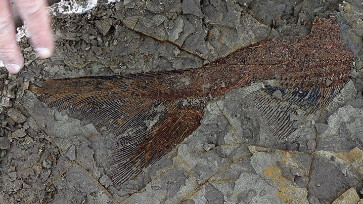
DePalma’s team says the [extinction] is captured in forensic detail in the 1.3-meter-thick Tanis deposit, which it says formed in just a few hours, beginning perhaps 13 minutes after impact. Although fish fossils are normally deposited horizontally, at Tanis, fish carcasses and tree trunks are preserved haphazardly, some in near vertical orientations, suggesting they were caught up in a large volume of mud and sand that was dumped nearly instantaneously.
The mud and sand are dotted with glassy spherules—many caught in the gills of the fish—isotopically dated to 65.8 million years ago. They presumably formed from droplets of molten rock launched into the atmosphere at the impact site, which cooled and solidified as they plummeted back to Earth. A 2-centimetre-thick layer rich in telltale iridium [a rare metal found in asteroids] caps the deposit.
Here it is: a day of planetary chaos locked into the geological record. The asteroid strike created tsunami-like conditions and threw water, fire, and debris for tens of thousands of kilometres in every direction. Ash, mud, fish, flora, and fauna ended up packed together and preserved in their bog within minutes. Raindrop-shaped glass fragments called tektites, forged in the heat of the impact, packed only the layer that caught them when they fell. A coating of black iridium is the day’s calling card and signals the end of both the Cretaceous period and the Mesozoic era.
It’s sheer luck that all of these things converged in this small area, but they did, and now it offers the most complete picture of a single day 66 million years in the past. If not for the events that day, though, it would be virtually impossible to isolate such a short stretch. So the answer here is both “yes, but” and “no, but” under the circumstances.
Thanks for sticking around to the end, friend! I had so much fun writing this one that I didn’t want to stop. Geology truly does rock.
If you’re wondering where the follow-up on the ice question is, Gmail is mad at me for how long this newsletter is. A short add-on post with those answers is coming your way in a few days! It’s already done, I just enjoy suspense.
You win this time, email overlords.